Decoding GIS data with Dr Matt Hobbs
Wondering how to turn your data into something meaningful? Expert Dr Matt Hobbs explains what you can do with GIS, and why it isn't just for 'map boffins'.


Wondering how to turn your data into something meaningful? Expert Dr Matt Hobbs explains what you can do with GIS, and why it isn't just for 'map boffins'.
Matt Hobbs
Sep 11, 2024
In today’s data-driven world, the ability to connect information to its geographic context is a powerful skill. Geographic Information Systems (GIS) allow us to visualise complex data on a map, helping us see our world in innovative ways. Dr Matt Hobbs is one of the experts behind our online GIS for Mapping micro-credential and shares his thoughts on how learning to use GIS technology can take your career to the next level.
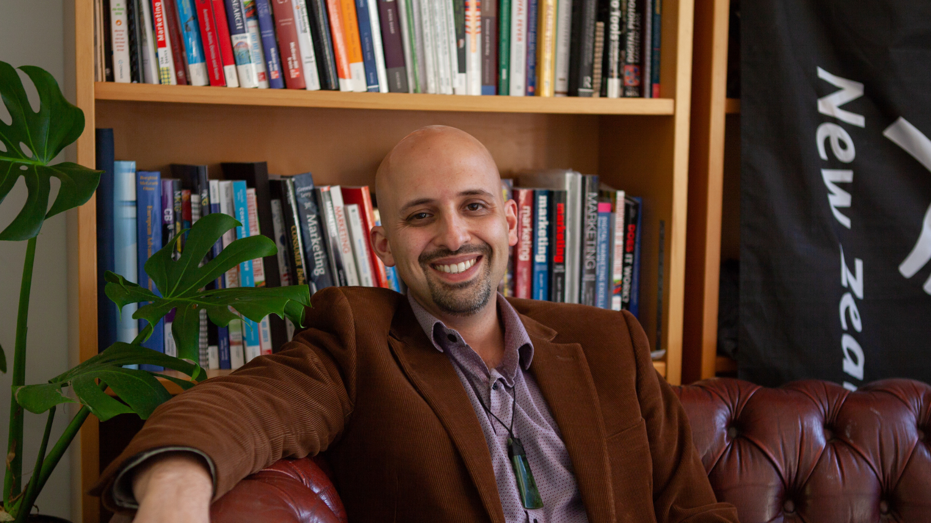
Matt is a Senior Lecturer (Above the Bar) in the Faculty of Health at Te Whare Wānanga o Waitaha | University of Canterbury as well as the Deputy Director of the GeoHealth Laboratory and part of the Geospatial Research Institute. Matt has provided expertise to government and other organisations across a range of topics including immunisation, water fluoridation and the relationship between liquor stores and crime.
For learners considering a career using GIS technology, what do you find most meaningful about researching and teaching in this field?
For me, working in the field of Geographic Information Systems (GIS) is particularly meaningful because it allows us to visualise and analyse spatial data in ways that can directly influence public health and social equity.
For example, recently my research on how vaping stores are distributed across different neighbourhoods in Aotearoa New Zealand has highlighted significant disparities in accessibility, even around our schools, and this can have profound implications for community health. By mapping these locations and analysing their proximity to schools and socioeconomically disadvantaged areas, GIS provides insights that can guide policy decisions and interventions aimed at reducing health risks associated with vape stores for young people.
For learners considering a career in GIS, the most compelling result is the ability to apply these tools to real-world problems, making data-driven decisions that can improve public health outcomes and ensure a more equitable distribution of resources. The interdisciplinary nature of GIS, combining elements of science, technology, and social research, makes it an exciting and impactful field to work in.
Why do we need to learn how to use GIS tools?
Learning how to harness GIS tools to create meaningful data has become increasingly critical in recent years due to the growing complexity of global challenges and the explosion of available data, especially spatial data. Unlike 5, 10, or even 20 years ago, we now have access to vast amounts of data and especially geospatial data, ranging from satellite imagery to real-time data from mobile devices. However, this data is only valuable if we can interpret it effectively to solve real-world problems. GIS tools enable us to analyse and visualise spatial relationships, uncover patterns, and make data-driven decisions that are crucial in fields like public health, environmental management, urban planning, and more.
In today's world, where issues like climate change, pandemics, and urbanisation require swift and informed responses, being able to create actionable insights from GIS data is more essential than ever. For example, understanding the spatial distribution of immunisation coverage can inform public health strategies, while analysing the proximity of green spaces can influence urban planning decisions that promote wellbeing. The need for these skills has never been greater, and GIS offers a powerful way to turn raw data into impactful, evidence-based solutions.

How can this course help learners advance or enter a career that uses GIS mapping software?
Our GIS for Mapping course is designed to be highly practical, equipping learners with hands-on experience in using GIS mapping software, which is essential for advancing or entering a career in this field. The course focuses on real-world applications, to provide students with the skills needed to create, interpret, and use spatial data effectively.
I really enjoy creating maps and working with spatial data, and while the course does cover theoretical concepts to build a strong foundation in GIS principles, the emphasis is on practical skills that can be directly applied in professional settings. By the end of the course, learners will have developed competency to use GIS tools in various industries, including urban planning, public health, environmental management, and more, giving you essential skills for any career that requires spatial analysis.
Image: Mapping vape stores across Aotearoa
The GeoHealth Lab recently published some research that Matt was part of – Breaking Through the Cloud: Vaping in Aotearoa New Zealand. They wanted to understand the spatial distribution of vape stores in Aotearoa New Zealand; where the stores are and how they change over time. Using GIS data and other data, they found about 30% of vape stores are within 400m of a school or kura. But schools in more deprived areas are more likely to have a vape store nearby. Read more about their research. The screenshot below is from an interactive map showing the results of this research.

Why do non-technical people need to understand GIS – or is this course more for the data enthusiasts?
Understanding GIS is definitely not just for data enthusiasts or 'map boffins'! It's increasingly essential for non-technical people across various fields. Whether you work in public health, urban planning, environmental management, or even business, understanding GIS can give you a powerful tool to make informed decisions based on spatial data.
For example, knowing how to interpret a map to show how health services such as hospitals, or more health concerning features like alcohol outlets or vape stores, are located in relation to socioeconomic areas can be crucial for developing effective public health strategies.
This course is designed to make GIS accessible to everyone, not just the 'map boffins'. It offers a practical introduction that empowers learners to use mapping software and spatial analysis tools, regardless of your background. By the end of the course, you'll have a solid understanding of how GIS can be applied in your field, enabling you to leverage this technology for better decision making and strategic planning.
What is your research specialty in GIS and how did your career bring you to this industry?
My research specialty in GIS focuses on examining the links between environmental exposures and health outcomes or health behaviours across various contexts. This includes studying the relationship between the proximity of alcohol outlets and hazardous drinking or crime rates, analysing how green space affects mental health outcomes across a lifespan, and investigating the impacts of air pollution on both physical and mental health during childhood. Additionally, I have been involved in mapping immunisation coverage, particularly in tracking maternal immunisation rates.
My career in this field began with a strong interest in public health, and I quickly realised the power of spatial analysis in uncovering patterns and disparities that are not immediately apparent through traditional methods. GIS has enabled me to combine my passion for health with cutting-edge technology, allowing me to explore how the environments we live in shape our health outcomes. This intersection of health and medical geography has driven my research, and I am committed to using GIS to address complex public health issues and promote equitable health outcomes for all populations.
We're excited to hear about your next research findings Matt – thanks for sharing your expertise with us!

Be the first to know about our new programmes and other online updates by subscribing to our newsletter.
Follow us on LinkedIn for the latest learning updates.
Subscribe to our newsletter.
Join our mailing list to receive the latest news and offers from Tuihono UC | UC Online.